Search
22 Apr 2026
Search
22 Apr 2026
Please allow ads as they help fund our trusted local news content.
Kindly add us to your ad blocker whitelist.
If you want further access to Ireland's best local journalism, consider contributing and/or subscribing to our free daily Newsletter .
Support our mission and join our community now.
To continue reading this article, you can subscribe for as little as €0.50 per week which will also give you access to all of our premium content and archived articles!
Alternatively, you can pay €0.50 per article, capped at €1 per day.
Thank you for supporting Ireland's best local journalism!


There is a possibility of heavy rain and flash flooding in several river catchment areas in Donegal.
The European Flood Awareness System (EFAS) has issued a flash flooding warning for the border region in the following river systems: Glen, Eany, Eske, Owenea, Owentocker, Gweebarra, Crolly and Reelin.
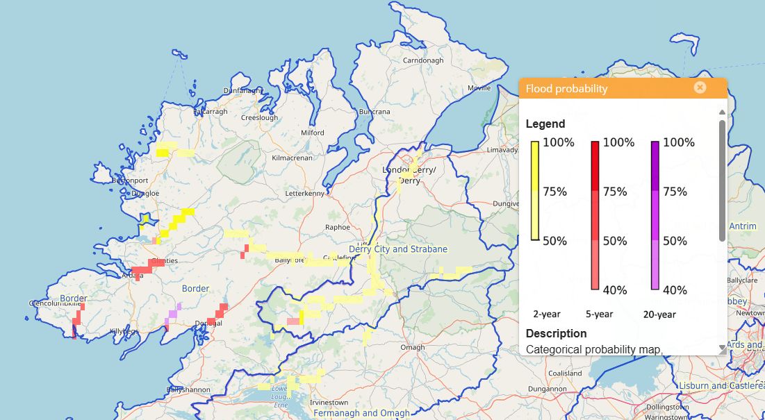
The flood probability % is included in the attached image.
EFAS has also issued a heightened flash flooding warning for Clady, Finn, and Erne (Pettigo), Derg, Mourne (Northern Ireland) confluence with River Finn at Lifford into the Foyle. The public is asked to take normal precautionary measures in these areas.
A status yellow rain warning for Donegal remains in effect until 8pm this evening. Impacts include widespread rain, which is expected to become heavy at times, leading to the possibility of localised flooding and difficult driving conditions.
A status yellow wind warning commences at 12 noon tomorrow, Friday, which will turn to a status orange wind warning at 2pm tomorrow afternoon until 10pm and revert to a status yellow until 12 noon on Saturday.
These wind warnings will bring near gale force to gale force and very gusty southwest to west winds. Impacts include fallen trees, damage to power lines and possible power outages, very difficult travelling conditions and possible wave overtopping.
A status yellow rain warning will come into effect tomorrow night at midnight and remain in place until midday on Saturday.
Additionally, a Status Red Marine warning is in place from Loop Head to Rossan Point to Fair Head - “Southwest to west winds may reach violent storm force 11 at times” – valid from 2pm tomorrow until 9pm.
READ NEXT: Thursday to be wet and blustery in Donegal with heavy rain and possible flooding
Storm Amy will bring strong to near gale-force and gusty southwesterly winds, with impacts including difficult travel conditions, the displacement of debris and loose objects, and the possibility of fallen trees. Trees are still in leaf at this time of the year, so there could be higher impacts from fallen trees and leaves blocking drains, causing localised flooding.
Donegal County Council’s Severe Weather Assessment Team have been monitoring the approaching weather pattern and will continue to monitor all local conditions as Storm Amy progresses.
Sandbags will be pre-deployed in a number of high-risk areas and further sandbags are ready to be deployed if required. Roads Service, Fire Service and Civil Defence crews are at a heightened state of readiness in the event of local responses being required during this storm event.
Donegal County Council can be contacted during normal business hours on 074 91 53900 and in the event of an out-of-hours emergency, the Council’s Road Service/Housing Department can be contacted on 074 91 72288. For emergencies requiring the assistance of the Fire Service, call 999 or 112.

Subscribe or register today to discover more from DonegalLive.ie
Buy the e-paper of the Donegal Democrat, Donegal People's Press, Donegal Post and Inish Times here for instant access to Donegal's premier news titles.
Keep up with the latest news from Donegal with our daily newsletter featuring the most important stories of the day delivered to your inbox every evening at 5pm.
This publication supports the work of the Press Council of Ireland and Office of the Press Ombudsman, and our staff operate within the Code of Practice of the Press Council. You can obtain a copy of the Code, or contact the Council, at www.presscouncil.ie, Lo-call 1800 208 080 or email: info@presscouncil.ie.


